


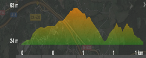
Type of route: 

Type of walk: Lineal.
Type of surface: Asphalt and cobbled road.
How to get there:
From the plaza de La Constitución, we take Ruamayor Street, through the Puebla Vieja. Arriving at the San Martín street, turn right and on the following corner, on San Marcial street, to the left. We enter the church enclosure.
Declared Value of Cultural Interest, the natural environment of La Atalaya contains the Rastrillar Fort: building ensemble that protected the bay from possible enemy ship attacks. Some buildings are from the XVI century and were funstioning until the beginning of the XX century. It occupies and extension of 41.500 m2.
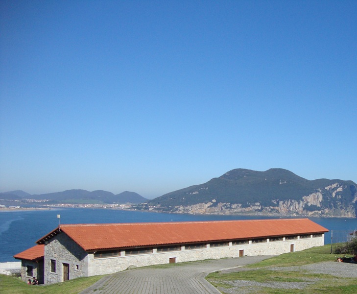
 We start at the Santa Mª de la Asunción church, where we can see a reproduction model of Laredo´s port from the XVI century. Circling the church we will find the path running by the cemetery on the left.
See on map
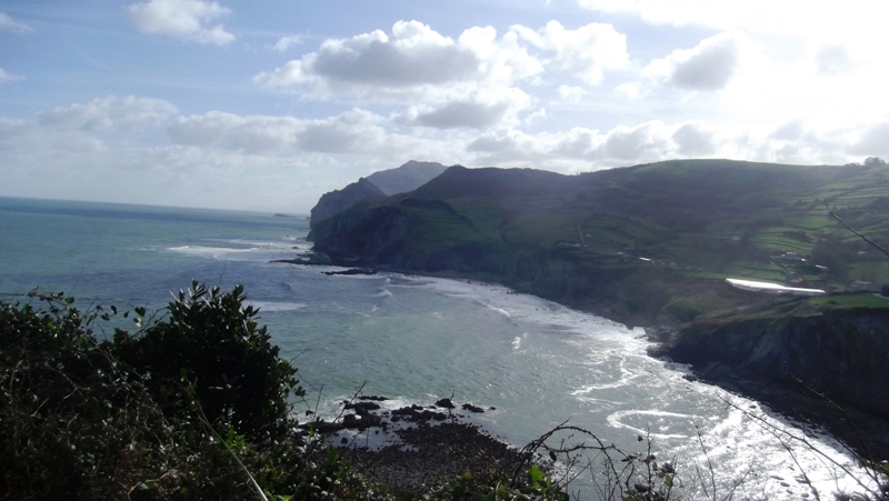
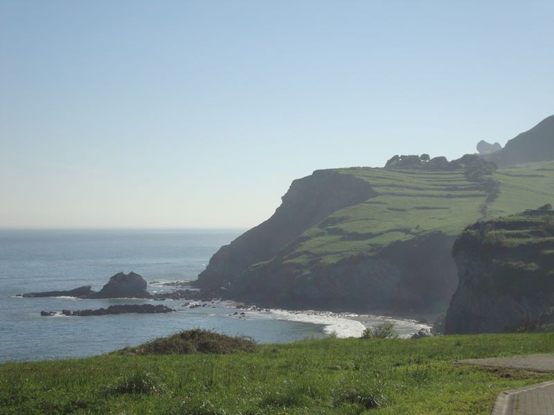 At the end of the path it is a good moment to stop, enjoy the fresh air and the scennery. To the right we will see cliffs, mountains and meadows.
See on map
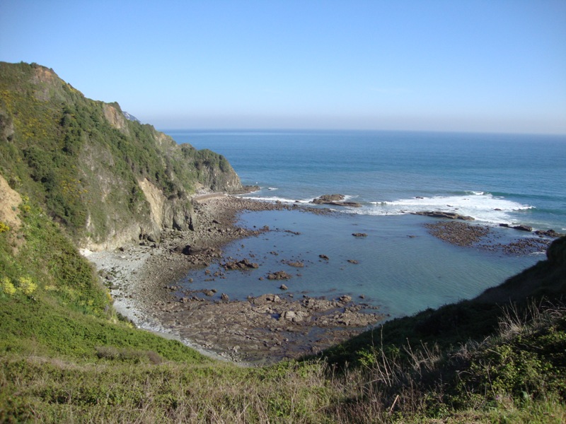 Opposite bellow, the La Soledad port. It was built around 1862 to the open sea, to avoid sand coming into the beach, which made access difficult for large boats. Various storms damaged this port (1873, 74 y 75) until it was finally abandoned. Another port was built at the beguining of the XXI century.
See on map
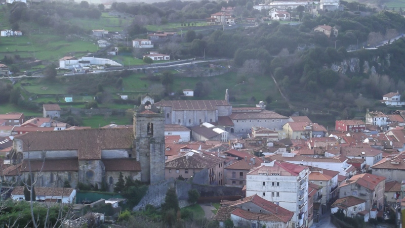 We continue walking towards our left, going up on a cobbled road until reaching a wide panoramic view of the whole town of Laredo and its bay. We can see the Puebla Vieja and the neirgbourhood of el Arrabal, medieval and jumbled, with grid streets.
See on map
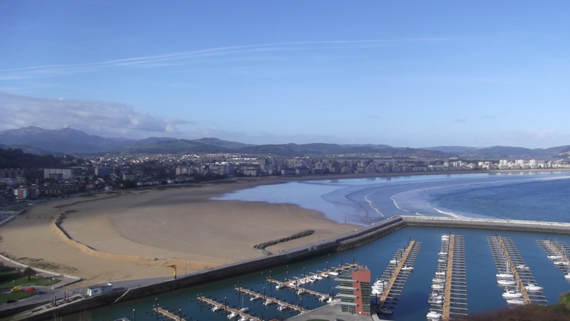 El Ensanche (the wide part), is where all services can be found and the beach stretching towards the Puntal.
See on map
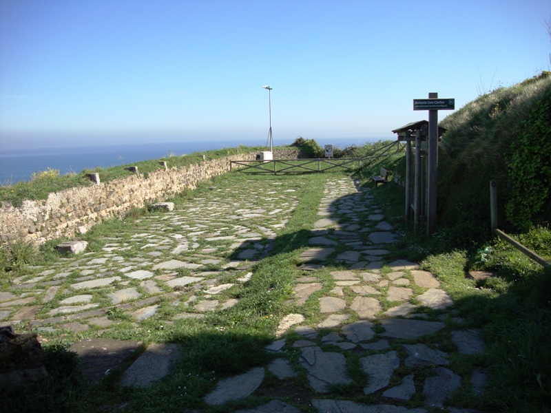
 When we enter the enclosure we see the La Caracola viewpoint, where Felipe II ordered to build the first battery. Here we can also find various buildings restored by the Escuela Taller: The troops pavilion housed 250 soldiers.
See on map
 We continue with the walk bordering the buildings and reaching a second viewpoint called la Rosa de los Vientos (rose of winds), place where the watchers were situated and warned the villagers when they saw any sign of whales near the coast. Men would get on their rowing boats to catch the whales.
See on map
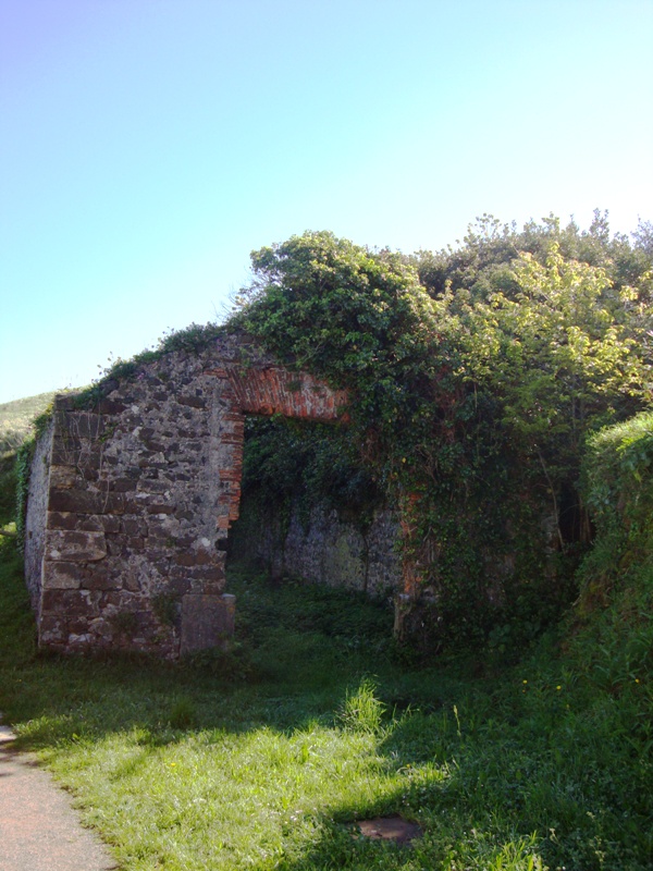
 Our steps take us to the battery of Santo Tomás. Its origin is Napoleonic.
At first, the cannons were installed in a wheeled shell over a wooden base, to allow for the recoil. Its range was between 800 to 1000 mts.
Our steps take us to the battery of Santo Tomás. Its origin is Napoleonic.
At first, the cannons were installed in a wheeled shell over a wooden base, to allow for the recoil. Its range was between 800 to 1000 mts.
See on map
 The ruins we see now are from Isabel II period. The wooden base was replaced by stone slabs. The cannons were installed on the stone slabs.
The line of bricks to shelter the area and shooth the damage of the enemy impact is still up.
The ruins we see now are from Isabel II period. The wooden base was replaced by stone slabs. The cannons were installed on the stone slabs.
The line of bricks to shelter the area and shooth the damage of the enemy impact is still up.
See on map
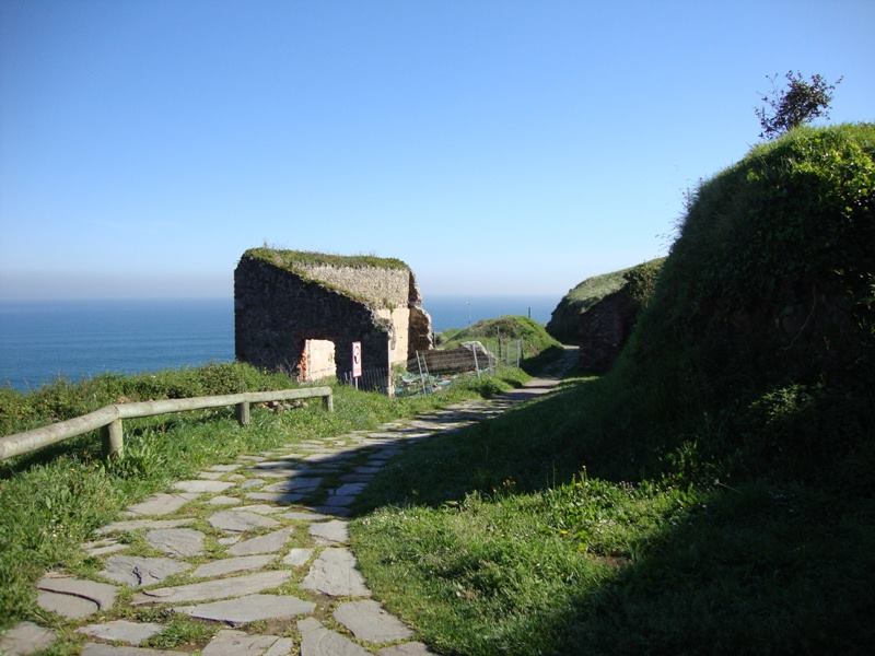 We walk down to go by the Cuerpo de Guardia, on the left we see the batteries of Santo Tomás and San Carlos. It was a building with bricked windows and hipped roofs.
See on map
 On the right we see the munition storage buildings with large doors to allow the entry of carts full of food and materials to cover the fort´s needs.
See on map
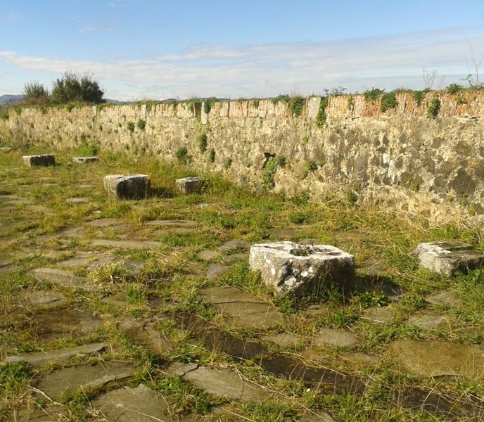
 We continue the walk to finish it, where the battery of San Carlos is situated. It is identical to the battery of Santo Tomás, although the line of bricks has disappeared.
Here is where the munitions dump is, situated on the hillside and with a circular corridor around it to minimize the impact in case of an explotion.
It is a windowless building, with hydrolic concrete cealing, covered with soild to disguise it. The munitions dump had two lighting rods. The munitions were stored in wooden barrels situated on shelves to avoid the humidity from the gound.
We continue the walk to finish it, where the battery of San Carlos is situated. It is identical to the battery of Santo Tomás, although the line of bricks has disappeared.
Here is where the munitions dump is, situated on the hillside and with a circular corridor around it to minimize the impact in case of an explotion.
It is a windowless building, with hydrolic concrete cealing, covered with soild to disguise it. The munitions dump had two lighting rods. The munitions were stored in wooden barrels situated on shelves to avoid the humidity from the gound.
See on map
We start at the Santa Mª de la Asunción church, where we can see a reproduction model of Laredo´s port from the XVI century. Circling the church we will find the path running by the cemetery on the left.
See on map
See on map
At the end of the path it is a good moment to stop, enjoy the fresh air and the scennery. To the right we will see cliffs, mountains and meadows.
See on map
See on map
Opposite bellow, the La Soledad port. It was built around 1862 to the open sea, to avoid sand coming into the beach, which made access difficult for large boats. Various storms damaged this port (1873, 74 y 75) until it was finally abandoned. Another port was built at the beguining of the XXI century.
See on map
See on map
We continue walking towards our left, going up on a cobbled road until reaching a wide panoramic view of the whole town of Laredo and its bay. We can see the Puebla Vieja and the neirgbourhood of el Arrabal, medieval and jumbled, with grid streets.
See on map
See on map
El Ensanche (the wide part), is where all services can be found and the beach stretching towards the Puntal.
See on map
See on map
When we enter the enclosure we see the La Caracola viewpoint, where Felipe II ordered to build the first battery. Here we can also find various buildings restored by the Escuela Taller: The troops pavilion housed 250 soldiers.
See on map
See on map
We continue with the walk bordering the buildings and reaching a second viewpoint called la Rosa de los Vientos (rose of winds), place where the watchers were situated and warned the villagers when they saw any sign of whales near the coast. Men would get on their rowing boats to catch the whales.
See on map
See on map
Our steps take us to the battery of Santo Tomás. Its origin is Napoleonic.
At first, the cannons were installed in a wheeled shell over a wooden base, to allow for the recoil. Its range was between 800 to 1000 mts.
See on map
See on map
The ruins we see now are from Isabel II period. The wooden base was replaced by stone slabs. The cannons were installed on the stone slabs.
The line of bricks to shelter the area and shooth the damage of the enemy impact is still up.
See on map
See on map
We walk down to go by the Cuerpo de Guardia, on the left we see the batteries of Santo Tomás and San Carlos. It was a building with bricked windows and hipped roofs.
See on map
See on map
On the right we see the munition storage buildings with large doors to allow the entry of carts full of food and materials to cover the fort´s needs.
See on map
See on map
We continue the walk to finish it, where the battery of San Carlos is situated. It is identical to the battery of Santo Tomás, although the line of bricks has disappeared.
Here is where the munitions dump is, situated on the hillside and with a circular corridor around it to minimize the impact in case of an explotion.
It is a windowless building, with hydrolic concrete cealing, covered with soild to disguise it. The munitions dump had two lighting rods. The munitions were stored in wooden barrels situated on shelves to avoid the humidity from the gound.
See on map
See on map