


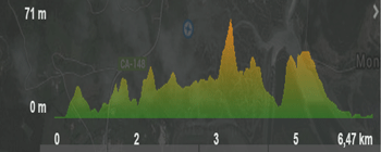
Type of route: ![]()
![]()
Type of walk: Circular.
Type of fsurface: Asphalt.
How to get there:
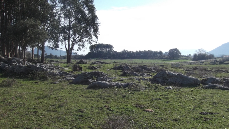
We are going to go all over Escalante mies (countryside). A mies is fields with agricultural and stock breeding purposes. It is a beautiful and relaxing walk, of great beauty and recommended for children too. It is sign posted with information boards about flora and other interesting subjects. There are benches along the walk to stop over and enjoy the scenery.
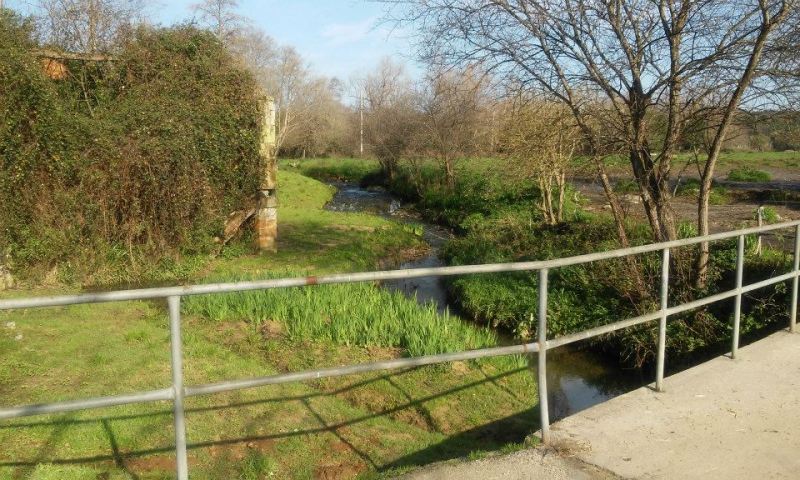 On the outskirts of Escalante, by the little bridge on the Pozeirún stream, we will find a cidery.
MUNICIPAL CIDERY: the Escalante Pomology Association, colaborating with the escalante Town Hall, celebrate since the year 2000 various actions to promote the cider. This initiative started merely to promote the folkloric side of the product. Later, the nieghbours, pay interest in plating apple trees to elaborate cider. The Town Hall responded building a cidery.
Today, more than 15 families elaborate this drink. In addition, the platations have developed in good apple trees, therefore, all the cider produced in Escalante is made with local apples.
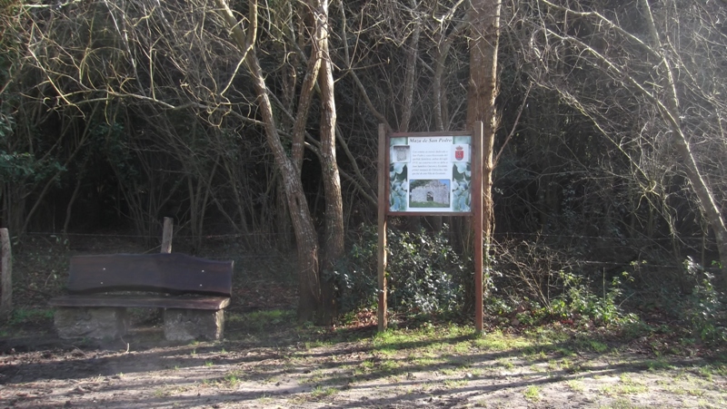
We cross the river and walk forwards. We will see a church on our left and will continue walking until we see an information board that indicates the “maza de San Pedro”.
On the outskirts of Escalante, by the little bridge on the Pozeirún stream, we will find a cidery.
MUNICIPAL CIDERY: the Escalante Pomology Association, colaborating with the escalante Town Hall, celebrate since the year 2000 various actions to promote the cider. This initiative started merely to promote the folkloric side of the product. Later, the nieghbours, pay interest in plating apple trees to elaborate cider. The Town Hall responded building a cidery.
Today, more than 15 families elaborate this drink. In addition, the platations have developed in good apple trees, therefore, all the cider produced in Escalante is made with local apples.
We cross the river and walk forwards. We will see a church on our left and will continue walking until we see an information board that indicates the “maza de San Pedro”.
See on map
 We carry on this path until arriving to a crosspath. Here we utrn right, La Lastra neighbourhood direction.
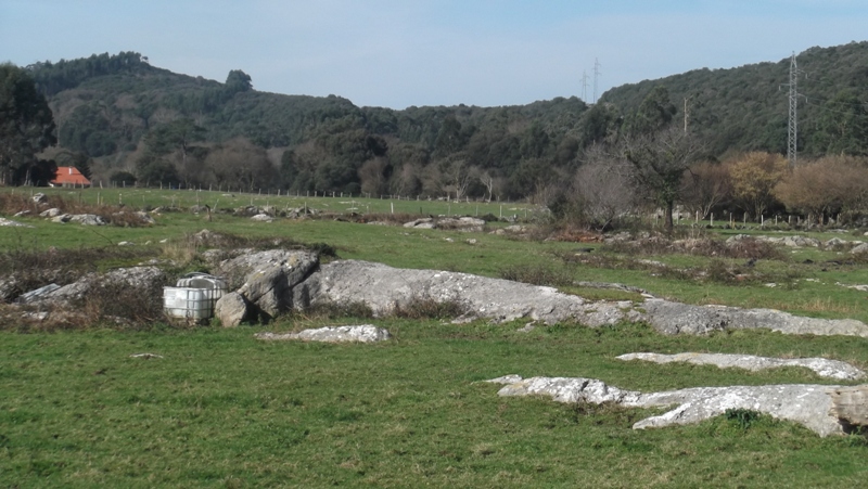
On both sides of this path we can see limestone flowers and stones that let us know this was seabed once. We also see Cantabrian Holm oak, Laurel and hawthorn forests. We should be aware of electrical fencing enclosures, do not touch these.
We carry on this path until arriving to a crosspath. Here we utrn right, La Lastra neighbourhood direction.
On both sides of this path we can see limestone flowers and stones that let us know this was seabed once. We also see Cantabrian Holm oak, Laurel and hawthorn forests. We should be aware of electrical fencing enclosures, do not touch these.
See on map
 We arrive to the neighbourhood of La Lastra, mostly stock breeder form the XIX cnetury, which we cross over and then turn left between the houses.
We continue until the next crosspath, where we will stop to see the beautiful auchtoctonous trees. There is an information board with explanations on these trees.
We arrive to the neighbourhood of La Lastra, mostly stock breeder form the XIX cnetury, which we cross over and then turn left between the houses.
We continue until the next crosspath, where we will stop to see the beautiful auchtoctonous trees. There is an information board with explanations on these trees.
See on map
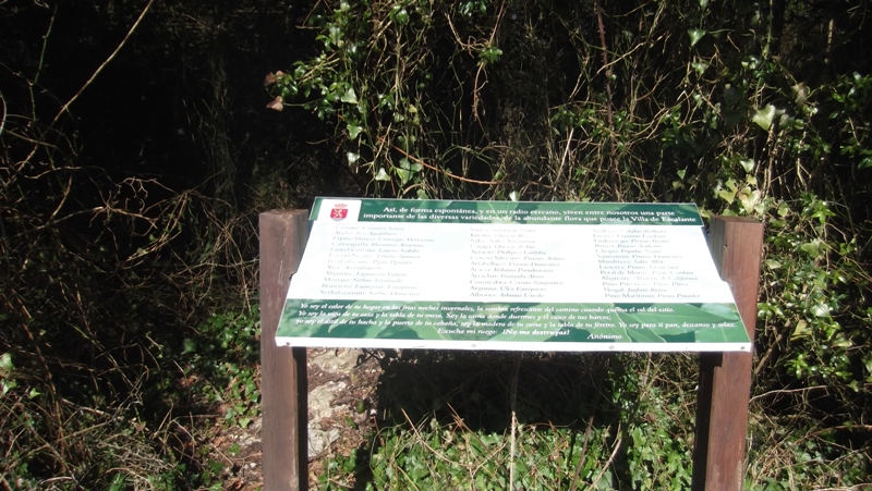 the information board gives an explanation on each of the trees species in the area.
See on map
 We continue forward, leaving the bench on the right, to walk towards the neighbourhood of Borroto where, we can see a two level house, hipped roof, wooden balcony and arches from the XVI century.
See on map
 We walk out of the neighbourhood turning right, until the next cross path. We turn left towards the neighbourhood of Baranda.
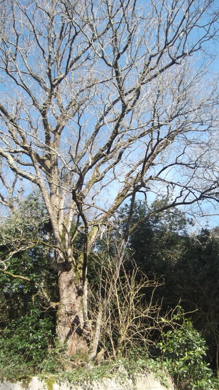
Before linking to the regional road S-402, we find a large cagiga (oak) with an information board indicating the dimensions of this specimen.
CAGIGA: they are robust trees, of big dimensions which can reach 40 metres of height, with thick short trunk. The leave is simple and big.
Its geographic distribution is tipically atlantic, of humid climate. In the old times these were the main componentes of forests in Cantabria, substituted by beech on high areas and by holm oaks on lime stone soil.
It is a symbolic tree, as a totem that represents the time of human beings in the world against the eternity of nature. This tree is loved to such an extreme that the eldest in the town say, in the 1920s t0 1930s, a mayor ended up in jail for cutting a forest of oaks. There is a song that says: "Because of the oaks nobody wants to be a mayor, as the mayor went to jail."
We walk out of the neighbourhood turning right, until the next cross path. We turn left towards the neighbourhood of Baranda.
Before linking to the regional road S-402, we find a large cagiga (oak) with an information board indicating the dimensions of this specimen.
CAGIGA: they are robust trees, of big dimensions which can reach 40 metres of height, with thick short trunk. The leave is simple and big.
Its geographic distribution is tipically atlantic, of humid climate. In the old times these were the main componentes of forests in Cantabria, substituted by beech on high areas and by holm oaks on lime stone soil.
It is a symbolic tree, as a totem that represents the time of human beings in the world against the eternity of nature. This tree is loved to such an extreme that the eldest in the town say, in the 1920s t0 1930s, a mayor ended up in jail for cutting a forest of oaks. There is a song that says: "Because of the oaks nobody wants to be a mayor, as the mayor went to jail."
See on map
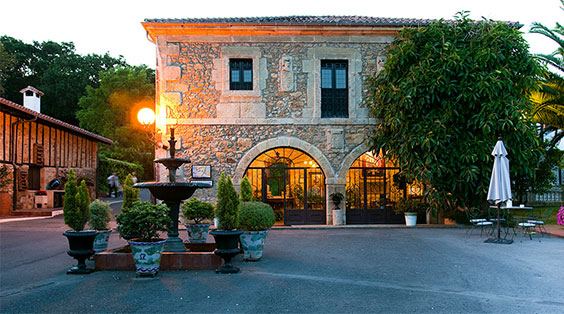 We continue forwards and arrive to the crossroads that links to the regional road S-402, where we turn right. We soon find the wall of the Jado house, from the XVII century, today renovated and turned into a hotel.
JADO HOUSE: It consists of a main body and a porch with the coat of arms of the Santelices family. The house shows three coats of arms from the families Trevilla, Velarde and Jado. Originally, this house belonged to the Santelices family until realted to the Jado family in 1729. The Jado house is quite old. During the conquest of Tangier and Ceuta, one of the members of the family stayed in a castle and from that time it was called "Dejado" (the abandoned one) derived in the name of Jado in 1504. Near by we can find other houses, such as Castillo, with chapel, Venero, with a solar tower in Castillo (Arnuero) or Puente Somaza.
We continue forwards and arrive to the crossroads that links to the regional road S-402, where we turn right. We soon find the wall of the Jado house, from the XVII century, today renovated and turned into a hotel.
JADO HOUSE: It consists of a main body and a porch with the coat of arms of the Santelices family. The house shows three coats of arms from the families Trevilla, Velarde and Jado. Originally, this house belonged to the Santelices family until realted to the Jado family in 1729. The Jado house is quite old. During the conquest of Tangier and Ceuta, one of the members of the family stayed in a castle and from that time it was called "Dejado" (the abandoned one) derived in the name of Jado in 1504. Near by we can find other houses, such as Castillo, with chapel, Venero, with a solar tower in Castillo (Arnuero) or Puente Somaza.
See on map
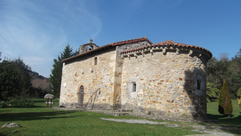 Crossing the road carefully we leave the hotel behind and find the San Román shrine of Escalante, form the end of the XII century, which constitutes a tresure for Escalante, as it is a beautiful architectonic example of coastal Roman style.
SAN ROMÁN DE ESCALANTE SHRINE: Declared Value of Cultural Interest in 1986, and in 2015. This small and humble shrine is a roman style building, with one nave of rectangular base and a deep presbitery that ends in semicircular apse, crowned by geometric brackets.
The nave is higher then the presbitery. It is built with masonry on walls and corners, window-door, ledge and archers. The nave is covered with wook.
Its chapel is masonry built. Inside, beautiful capitals and medieval sepulchre.
The image of the Virgen with child is a late version of images from the begining of the XII century with the same theme, such as the image of Nuestra Señora de la Majestad in the Astorga Cathedral, of gold and polycromated wood. The hieratical features, very vertical, lineal dress, the disposition of the feet, the shape of the shoes, etc...place the image of Escalante on this tradition.
The church is dedicated to San Román, a Saint closely linked to San Benito. This devotion is related to the monastery of Santa María del Puerto in Santoña, which depends on the San Román monastery.
It is situated in a walled enclosure with a garden where we can find laurel, wild roses, cypress and a large pine tree.
Crossing the road carefully we leave the hotel behind and find the San Román shrine of Escalante, form the end of the XII century, which constitutes a tresure for Escalante, as it is a beautiful architectonic example of coastal Roman style.
SAN ROMÁN DE ESCALANTE SHRINE: Declared Value of Cultural Interest in 1986, and in 2015. This small and humble shrine is a roman style building, with one nave of rectangular base and a deep presbitery that ends in semicircular apse, crowned by geometric brackets.
The nave is higher then the presbitery. It is built with masonry on walls and corners, window-door, ledge and archers. The nave is covered with wook.
Its chapel is masonry built. Inside, beautiful capitals and medieval sepulchre.
The image of the Virgen with child is a late version of images from the begining of the XII century with the same theme, such as the image of Nuestra Señora de la Majestad in the Astorga Cathedral, of gold and polycromated wood. The hieratical features, very vertical, lineal dress, the disposition of the feet, the shape of the shoes, etc...place the image of Escalante on this tradition.
The church is dedicated to San Román, a Saint closely linked to San Benito. This devotion is related to the monastery of Santa María del Puerto in Santoña, which depends on the San Román monastery.
It is situated in a walled enclosure with a garden where we can find laurel, wild roses, cypress and a large pine tree.
See on map
 Continue on the dirt track leaving the shrine on our right. This path, after a 90º turn, will situate us paralel to the regional road S-402. Carry on walking paralel to the road until arriving to the neighbourhood of el Noval, where we can find the Santa Clara convent. This neighbourhood is formed by a beautiful historic ensemble where all buildings surround a central plaza and are linked to the stock breeding activities.
We soon find the Santa Clara convent, reaching the road.
The San Juan de Montecalvario de Escalante convent was founded in 1603 by Juan de Castillo Río. The person in charge was Alonso de Camino.
It is a simple church, with one nave, covered by a dome and flat back wall. Its decoration is reduced to an altar piece, from 1665.
Space for the Camino de Santiago pilgrims has been created here.
By the Santa Clara convent, we find the San Roque shrine. From the XVII century. Neogothic style.
Continue on the dirt track leaving the shrine on our right. This path, after a 90º turn, will situate us paralel to the regional road S-402. Carry on walking paralel to the road until arriving to the neighbourhood of el Noval, where we can find the Santa Clara convent. This neighbourhood is formed by a beautiful historic ensemble where all buildings surround a central plaza and are linked to the stock breeding activities.
We soon find the Santa Clara convent, reaching the road.
The San Juan de Montecalvario de Escalante convent was founded in 1603 by Juan de Castillo Río. The person in charge was Alonso de Camino.
It is a simple church, with one nave, covered by a dome and flat back wall. Its decoration is reduced to an altar piece, from 1665.
Space for the Camino de Santiago pilgrims has been created here.
By the Santa Clara convent, we find the San Roque shrine. From the XVII century. Neogothic style.
See on map
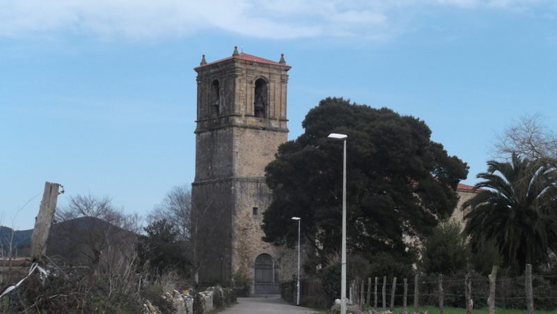 We cross the road and 100 metres on the right we will find the Santa Cruz church, this is part of the Camino de Santiago. It is a baroque tower that marked the daily rythm of the town.
Its origin is the XIV century, time in which the building was linked to the families of Ceballos y Guevara. The church was built between the XVI and XVII centuries, the Santiago chapel being the eldest part, with a dome supported by sei-circular columns.
The church has one nave with side chapels and a high door on the front together with the bells body and the tower, are some of the most emblematic elements.
The tower is baroque, one of the best in the region, built in 1702. The tower has three levels and a porch inside. It use was delimited to announcing mass and marking the working hours, the neighbour meetings and fires.
Inside there is a well preserved altar piece from 1730, of large dimensions and freat quality. The sanctuary is of great importance, two levels and octagonal base.
End of route
From the church we take the path back to the village, crossing the nieghbourhood of santa Cruz until arriving to the starting point.
We cross the road and 100 metres on the right we will find the Santa Cruz church, this is part of the Camino de Santiago. It is a baroque tower that marked the daily rythm of the town.
Its origin is the XIV century, time in which the building was linked to the families of Ceballos y Guevara. The church was built between the XVI and XVII centuries, the Santiago chapel being the eldest part, with a dome supported by sei-circular columns.
The church has one nave with side chapels and a high door on the front together with the bells body and the tower, are some of the most emblematic elements.
The tower is baroque, one of the best in the region, built in 1702. The tower has three levels and a porch inside. It use was delimited to announcing mass and marking the working hours, the neighbour meetings and fires.
Inside there is a well preserved altar piece from 1730, of large dimensions and freat quality. The sanctuary is of great importance, two levels and octagonal base.
End of route
From the church we take the path back to the village, crossing the nieghbourhood of santa Cruz until arriving to the starting point.
See on map
On the outskirts of Escalante, by the little bridge on the Pozeirún stream, we will find a cidery.
MUNICIPAL CIDERY: the Escalante Pomology Association, colaborating with the escalante Town Hall, celebrate since the year 2000 various actions to promote the cider. This initiative started merely to promote the folkloric side of the product. Later, the nieghbours, pay interest in plating apple trees to elaborate cider. The Town Hall responded building a cidery.
Today, more than 15 families elaborate this drink. In addition, the platations have developed in good apple trees, therefore, all the cider produced in Escalante is made with local apples.
We cross the river and walk forwards. We will see a church on our left and will continue walking until we see an information board that indicates the “maza de San Pedro”.
See on map
See on map
We carry on this path until arriving to a crosspath. Here we utrn right, La Lastra neighbourhood direction.
On both sides of this path we can see limestone flowers and stones that let us know this was seabed once. We also see Cantabrian Holm oak, Laurel and hawthorn forests. We should be aware of electrical fencing enclosures, do not touch these.
See on map
See on map
We arrive to the neighbourhood of La Lastra, mostly stock breeder form the XIX cnetury, which we cross over and then turn left between the houses.
We continue until the next crosspath, where we will stop to see the beautiful auchtoctonous trees. There is an information board with explanations on these trees.
See on map
See on map
the information board gives an explanation on each of the trees species in the area.
See on map
See on map
We continue forward, leaving the bench on the right, to walk towards the neighbourhood of Borroto where, we can see a two level house, hipped roof, wooden balcony and arches from the XVI century.
See on map
See on map
We walk out of the neighbourhood turning right, until the next cross path. We turn left towards the neighbourhood of Baranda.
Before linking to the regional road S-402, we find a large cagiga (oak) with an information board indicating the dimensions of this specimen.
CAGIGA: they are robust trees, of big dimensions which can reach 40 metres of height, with thick short trunk. The leave is simple and big.
Its geographic distribution is tipically atlantic, of humid climate. In the old times these were the main componentes of forests in Cantabria, substituted by beech on high areas and by holm oaks on lime stone soil.
It is a symbolic tree, as a totem that represents the time of human beings in the world against the eternity of nature. This tree is loved to such an extreme that the eldest in the town say, in the 1920s t0 1930s, a mayor ended up in jail for cutting a forest of oaks. There is a song that says: "Because of the oaks nobody wants to be a mayor, as the mayor went to jail."
See on map
See on map
We continue forwards and arrive to the crossroads that links to the regional road S-402, where we turn right. We soon find the wall of the Jado house, from the XVII century, today renovated and turned into a hotel.
JADO HOUSE: It consists of a main body and a porch with the coat of arms of the Santelices family. The house shows three coats of arms from the families Trevilla, Velarde and Jado. Originally, this house belonged to the Santelices family until realted to the Jado family in 1729. The Jado house is quite old. During the conquest of Tangier and Ceuta, one of the members of the family stayed in a castle and from that time it was called "Dejado" (the abandoned one) derived in the name of Jado in 1504. Near by we can find other houses, such as Castillo, with chapel, Venero, with a solar tower in Castillo (Arnuero) or Puente Somaza.
See on map
See on map
Crossing the road carefully we leave the hotel behind and find the San Román shrine of Escalante, form the end of the XII century, which constitutes a tresure for Escalante, as it is a beautiful architectonic example of coastal Roman style.
SAN ROMÁN DE ESCALANTE SHRINE: Declared Value of Cultural Interest in 1986, and in 2015. This small and humble shrine is a roman style building, with one nave of rectangular base and a deep presbitery that ends in semicircular apse, crowned by geometric brackets.
The nave is higher then the presbitery. It is built with masonry on walls and corners, window-door, ledge and archers. The nave is covered with wook.
Its chapel is masonry built. Inside, beautiful capitals and medieval sepulchre.
The image of the Virgen with child is a late version of images from the begining of the XII century with the same theme, such as the image of Nuestra Señora de la Majestad in the Astorga Cathedral, of gold and polycromated wood. The hieratical features, very vertical, lineal dress, the disposition of the feet, the shape of the shoes, etc...place the image of Escalante on this tradition.
The church is dedicated to San Román, a Saint closely linked to San Benito. This devotion is related to the monastery of Santa María del Puerto in Santoña, which depends on the San Román monastery.
It is situated in a walled enclosure with a garden where we can find laurel, wild roses, cypress and a large pine tree.
See on map
See on map
Continue on the dirt track leaving the shrine on our right. This path, after a 90º turn, will situate us paralel to the regional road S-402. Carry on walking paralel to the road until arriving to the neighbourhood of el Noval, where we can find the Santa Clara convent. This neighbourhood is formed by a beautiful historic ensemble where all buildings surround a central plaza and are linked to the stock breeding activities.
We soon find the Santa Clara convent, reaching the road.
The San Juan de Montecalvario de Escalante convent was founded in 1603 by Juan de Castillo Río. The person in charge was Alonso de Camino.
It is a simple church, with one nave, covered by a dome and flat back wall. Its decoration is reduced to an altar piece, from 1665.
Space for the Camino de Santiago pilgrims has been created here.
By the Santa Clara convent, we find the San Roque shrine. From the XVII century. Neogothic style.
See on map
See on map
We cross the road and 100 metres on the right we will find the Santa Cruz church, this is part of the Camino de Santiago. It is a baroque tower that marked the daily rythm of the town.
Its origin is the XIV century, time in which the building was linked to the families of Ceballos y Guevara. The church was built between the XVI and XVII centuries, the Santiago chapel being the eldest part, with a dome supported by sei-circular columns.
The church has one nave with side chapels and a high door on the front together with the bells body and the tower, are some of the most emblematic elements.
The tower is baroque, one of the best in the region, built in 1702. The tower has three levels and a porch inside. It use was delimited to announcing mass and marking the working hours, the neighbour meetings and fires.
Inside there is a well preserved altar piece from 1730, of large dimensions and freat quality. The sanctuary is of great importance, two levels and octagonal base.
End of route
From the church we take the path back to the village, crossing the nieghbourhood of santa Cruz until arriving to the starting point.
See on map
See on map