


 The Asón River, along its 44 kms of lenght, forms a rich natural space which ecological value is recognized by the protection figures of: (SPAs) Special Protected Area for birds and (SCI) Site of Community Importance.
The river is born at 680 m. of hight, in the Collados del Asón Nature Park, causing an espectacular 50 m. waterfall in the shape of a horse tail. The Gándar River, hte main tributary, is born near by. Both rivers flow through different valleys to join in Ramales de la Victoria.
Its HIGH COURSE´s main features are the steep slopes. It is because of this that every november the Copa Cántabra de Kayak Extremo (brave waters time-trail race) is celebrated. It is on this section of the river that the tributary Bustablo River joins the River Asón.
In its MIDDLE COURSE the river receives waters form the atributaries Calera, Carranza, Silencio, Ruhermosa and Vallino Rivers. Between Rasines and Ampuero, the wally widens and the river waters form a pool offering magnificent bathing spots. Recreational and swimming designated areas.
It is in this river course where, for more than 60 years, a yearly International Descent of the Asón River is celebrated. The best national canoeists attend to this espectacular event.
The Asón River is known by the existence of abundant trout and salmon. Every spring the catch of the “Campanu” (first catched salmon of the season) is reason for a party. There are fisherman shelters and fishing preserves.
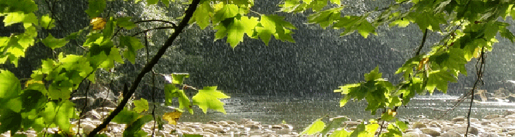
Common river flora an fauna are abundant, such as black poplar, alder trees, chesnuts, ducks, herons…
In its LOWER COURSE, on the way to the river´s mouth by the Santoña, Victoria and Joyel Nature Park, the Limpias estuary is formed joining Rada estuary receiving waters from the Clarín and Clarón Rivers in the Aras Valley (Voto).
It is here where we can find the faunistic richness of the marshes (spoonbills, herons, ducks, provers…), which use this ecosystem as a resting place before migrating towards warmer places.
Recreational and wimming areas
Vegacorredor Public Park (Ramales de la Victoria)
Getting there: at the entrance of Ramales de la Victoria (road N-629, coming from the coast) we will see a turning to the right (CA-261) with signs to un desvío Valle and Arredondo. After about 1 Km we will see a wooden sign on the left, indicating the entrance to the Park.
Description: The Vegacorredor recreational area is a large extention of woods where the river forms a pool, ideal for swimming. It is a great place to spend a pleasant day in touch with nature.
Facilities: wooden tables, barbacues, drinking water, playground and car park. Toiltes are only available in the two near by existing bars, one at the entrace of the park and the second one at the other end of the park.
Gandasón-Cubillas Public Park (Ramales de la Victoria)
Getting there: 1 km before arriving to Ramales de la Victoria (road N-629, coming from the coast) we will see a turning to the right with signs for the neighbouhood of Cubillas, going over the river through a birdge.
Description: large area with woods, bathed by the river. An ideal place to enjoy with family and friends.
Facilities: wooden tables, drinking water, barbacues, playground, car park and sport facilities: football pitch, bowling alley or basketball pitch. From this place you can take a river path with easy access to enjoy a pleasant walk or cycle. Toilets available in the bar.
Coto Cuende (Gibaja, Ramales de la Victoria)
Getting there: road N-629, towards Ramales de la Victoria, we turn in Gibaja, by the train station, where we can leave the vehicle. At the opossite there is a path that borders the river for about 20 minutes and takes us to El Cuende reserve. No signs available.
Description: Some periods of time during the year swimming is forbiden in this area, as it is a hunting ground. This is where the river forms a pool, with abundant vegetation: hazel trees, black poplars… A beautiful stone fisherman shelter can be found here.
Facilities: pure nature, no facilities available.
La Presa Park (Ampuero)
Getting there: There are two ways of getting there:
1.- By car: we follow the road N-629 towards Rasines. In the town outskirts, passed LaPinta restaurant, we take the first one right to the Antonio Ruiz Ruiz Street, which will take us to the dam.
2.- On foot: we can also access it by the pedestrian path access to the también La Presa Park. On this occasion we take the turning to the Bien Aparecida sanctuary and, shortly after the Health Center (opossite the bullfighting arena), we will see a sign on the left which will indicate the pedestrian path.
Description: Asón river dam used as a swimming area. The river is accessed by a rocky area. It is an attractive large park with woods where you can spend a lovely day in touch with nature.
Facilities: wooden tables and benches, playground and car park area. Very close to the dam there is a municipal pool and the Casa de La Presa, where you can find a bar and toilets.
Udalla: Bridge area
Getting there: From Ampuero, we follow the road signs to Udalla (CA-685). Once in the town we follow the road over a river through a bridge situated by two bars.
Description: Here is where the river forms a pool and there are large rocks thata make the access to the water easier.
Facilities: there is a little area with wooden tables and barbacues and two bars where toilets are available. This is also a starting point for the reverbank route with information boards. At the end of the route, by the fisherman shelter, we will find another wooden tables area.