


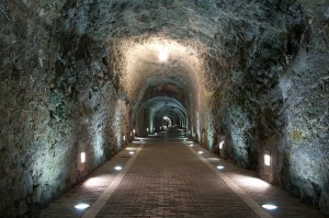
 The tunnel
Situated under the mount of Atalaya, at the end of the Menéndez Pelayo Street, it was built in 1863 to be able to build the bridge of Muelle de la Soledad, to the otehr side of the mount Atalaya. The remains of the bridge were destroyed by sea storms.
 The tunnel
During the Spanish Civil War it was used occasionally as a refuge against the aviation attacks.
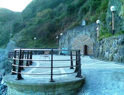
It is 221 m. long and at the end we will find the viewpoint Mirador del Abra totally integrated in the natural environment and from where we can contemplate the Laredo coast and access by foot the area of cliffs and the El Aila cove, when the tide is low.
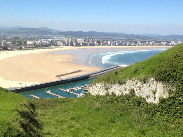
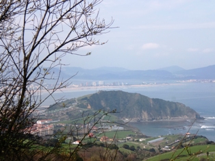 La Atalaya Mount (Vantage point)
The name Atalaya is due for being the place where the watchers, vigilants, warned the town when the whales approached the coast. Once on the rowing boats, men would go hunting. The whales were an important source of food for the population in times of food scarcity.
+ More information
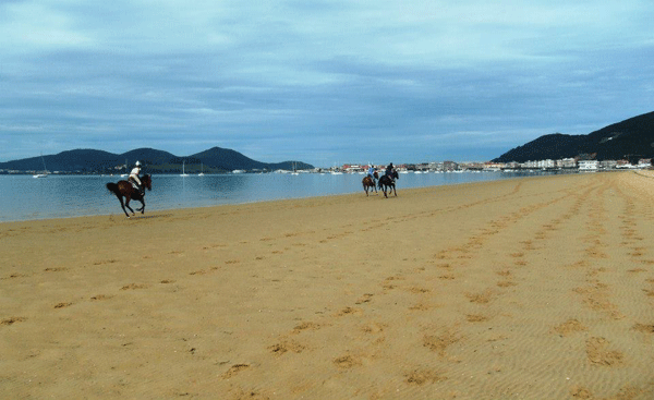 Regatón beach
The estuary of the Asón river and the Regatón beach are integrated within the Santoña, Vicoria and Joyel Marshes Nature Park, important wetland in the norht of Spain with diverse environmental values, such as the migratory birds.
+ More information
 Beaches
Regatón beach and La Salvé beach.
+ More information
The tunnel
Situated under the mount of Atalaya, at the end of the Menéndez Pelayo Street, it was built in 1863 to be able to build the bridge of Muelle de la Soledad, to the otehr side of the mount Atalaya. The remains of the bridge were destroyed by sea storms.
Situated under the mount of Atalaya, at the end of the Menéndez Pelayo Street, it was built in 1863 to be able to build the bridge of Muelle de la Soledad, to the otehr side of the mount Atalaya. The remains of the bridge were destroyed by sea storms.
The tunnel
During the Spanish Civil War it was used occasionally as a refuge against the aviation attacks. It is 221 m. long and at the end we will find the viewpoint Mirador del Abra totally integrated in the natural environment and from where we can contemplate the Laredo coast and access by foot the area of cliffs and the El Aila cove, when the tide is low.
During the Spanish Civil War it was used occasionally as a refuge against the aviation attacks. It is 221 m. long and at the end we will find the viewpoint Mirador del Abra totally integrated in the natural environment and from where we can contemplate the Laredo coast and access by foot the area of cliffs and the El Aila cove, when the tide is low.
La Atalaya Mount (Vantage point)
The name Atalaya is due for being the place where the watchers, vigilants, warned the town when the whales approached the coast. Once on the rowing boats, men would go hunting. The whales were an important source of food for the population in times of food scarcity.
+ More information
The name Atalaya is due for being the place where the watchers, vigilants, warned the town when the whales approached the coast. Once on the rowing boats, men would go hunting. The whales were an important source of food for the population in times of food scarcity.
+ More information
Regatón beach
The estuary of the Asón river and the Regatón beach are integrated within the Santoña, Vicoria and Joyel Marshes Nature Park, important wetland in the norht of Spain with diverse environmental values, such as the migratory birds.
+ More information
The estuary of the Asón river and the Regatón beach are integrated within the Santoña, Vicoria and Joyel Marshes Nature Park, important wetland in the norht of Spain with diverse environmental values, such as the migratory birds.
+ More information
Beaches
Regatón beach and La Salvé beach.
+ More information
Regatón beach and La Salvé beach.
+ More information